
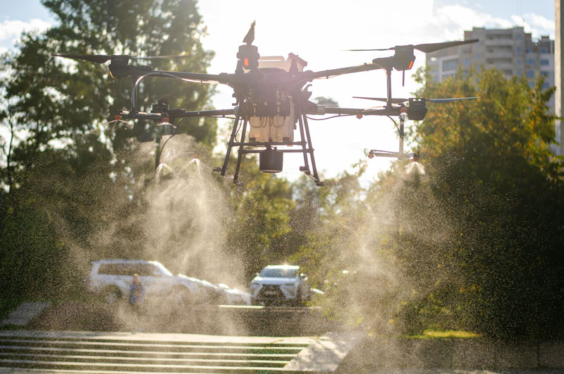
Revolutionize your agriculture with our drones
Precision agriculture using aerial imagery and data analysis for your crops is a must-have technology. Agriculture is going through a period of transformation, driven by major challenges such as climate change, resource scarcity, regulatory pressures and increasingly competitive markets.
To meet these challenges, farmers and other industry players need to innovate using new technologies. It’s in this context that agricultural drones are emerging as an essential performance lever, with the help of our experts.
Our precision agriculture drone service is aimed at agricultural producers, cooperatives and agronomic advisors who want to make decisions based on concrete data.
Applications and benefits:
- Crop health monitoring: identification of stressed areas, assessment of plant vigor.
- Disease and pest detection: early identification of infestations for rapid intervention.
- Precise mapping for optimum management: use of geo-referenced maps for irrigation planning, fertilization and crop protection.
What is precision agriculture?
Precision agriculture refers to a set of agronomic and digital techniques designed to optimize production on an intra-parcel scale. The aim is to analyze the natural variability of soils and crops. Thanks to technologies such as GPS, intelligent sensors, drones and the expertise of our team, farmers have access to geo-referenced data enabling them to take targeted action. How does this agricultural imagery service work? By reducing inputs (water, fertilizers, phytosanitary products), improving work efficiency and speeding up decision-making. The drone, with its ability to capture the evolution of crops in real time, enables crop monitoring, mapping, plant health and general land management.
Why use precision farming and drone imagery?
Precision farming by drone is transforming the way crops are monitored, analyzed and managed. Unlike traditional methods, aerial drone imagery provides accurate, rapid and actionable data on plant health, soil variability and input management. Using an agricultural drone in precision farming offers several strategic advantages:
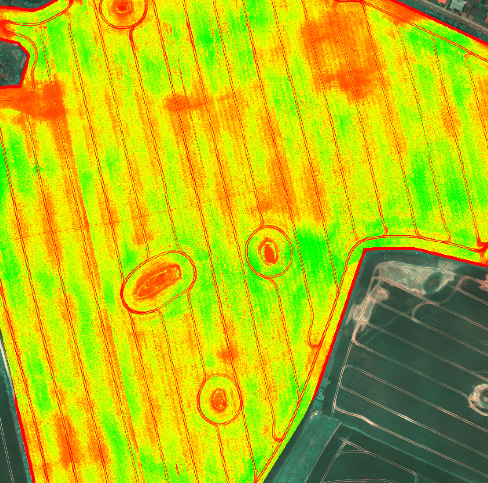
Detailed observation: thanks to multispectral mapping, areas of water stress, nutrient deficiencies or disease can be quickly detected before they become visible to the naked eye.
Optimization of agricultural inputs: the data collected enables the precise targeting of areas requiring treatment, thus reducing the use of fertilizers, water and phytosanitary products.
Improved yields: By intervening earlier and more effectively, farmers can increase the productivity of their plots while preserving crop health.
Lower operating costs: Fewer inputs, less mechanical intervention and better allocation of resources mean lower production costs.
Tracking plot evolution: drone imagery enables data to be compared from one season to the next, facilitating decision-making on crop rotations and land management.
By integrating drone-based agricultural mapping technologies into your operation, you have a powerful tool for managing your crops with precision, profitability and sustainability.
Precision farming: a strategic lever for farms?
The drone has established itself as a monitoring and decision-making tool in agriculture. It flies over fields at low altitude, taking highly accurate images and readings unattainable by satellite or light aircraft.
Thanks to specific sensors (multispectral, thermal, LiDAR…), it enables us to observe plant health via indices such as NDVI, which reveal chlorophyll levels and therefore crop vigor. Identifying stressed areas to anticipate irrigation, fertilization or phytosanitary treatments becomes easier thanks to this technology. Geolocate anomalies such as damage caused by pests, diseases or deficiencies.
This rapid data collection provides a solid, dynamic analysis of crop evolution, enabling cultivation practices to be adjusted in near-real time.
Why use the data collected with intelligent agriculture?
Intelligent agriculture brings together a range of digital tools to improve farm management. Connected sensors, weather stations, IoT objects and, above all, drones collect real-time information on the condition of crops. This data is then aggregated, compared and transformed into detailed reports by our team.
What are the advantages of precision farming?
Precision farming by drone is revolutionizing the way farms are managed, by providing a clear, rapid and objective view of your plots. Thanks to aerial imagery and data analysis technologies, you can maximize the efficiency of your interventions and sustainably improve your productivity. There are many advantages to using this service, including :
- Precise, rapid analysis of crop condition: drones equipped with multispectral and thermal sensors detect variations in plant health in real time, long before any signs are visible to the naked eye.
- Proactive responses to threats: By quickly identifying disease, water stress or pest infestations, you can intervene effectively and limit yield losses.
- Data centralization: The results of agricultural drone mapping are integrated into farm management software, facilitating monitoring, planning and overall analysis of your farm.
- Considerable time savings: With direct access to intervention maps and targeted analyses, you can make faster decisions, while optimizing your human and material resources.
What concrete benefits can precision farming bring to farmland?
Optimizing crop yields
Farmers who adopt a drone-based precision farming service often see a significant increase in crop yields within the first few months. Precise diagnostics enable an adapted response to needs: localized treatment, correction of deficiencies, or adjustment of water inputs. The result: healthier plants, less depleted soil, and maximized production.
Precision farming reduces costs and inputs
One of the major promises of this technology is the drastic reduction in inputs: fertilizers, water, fuel and labor. By treating only the necessary areas, farmers save money while complying with environmental regulations.
Drones are part of a virtuous circle:
Fewer inputs → less ecological impact,
Fewer emissions → respect for the environment,
Less unnecessary work → more time for analysis and continuous improvement.
Continuous monitoring and risk management
Agricultural seasons are subject to many variables: the vagaries of the weather, the proliferation of pests and plant diseases. Regular drone surveillance can identify problems immediately, often before they become critical. This makes agriculture more predictive, more far-sighted, and enables proactive agricultural risk management.
Here are a few concrete examples of the benefits of precision farming:
- Observe your crops in detail, on a scale that’s impossible on the ground.
- Optimizing irrigation by detecting dry areas
- Precision seeding with intra-plot variability analysis
- Early detection of pests and diseases
- Monitor the effect of a specific fertilizer or treatment
- Support for agronomic planning or crop rotation
Important note: According to studies by Université Laval, precision farming can reduce inputs by 20-30% while increasing productivity by 10-15%.
What we offer
Our agricultural drone mapping service is carried out by certified professionals specialized in precision agriculture. Each report includes :
- Multispectral imaging (NDVI, GNDVI) for plant health analysis
- Mapping plots: water stress, deficiencies, diseases
- Creation of prescription cards for targeted interventions
- Terrain modeling (contours, drainage, orthophotos)
- Complete report delivered in PDF and GIS formats (GeoTIFF, SHP)
Our drone inspections cover row crops, field crops, orchards, vineyards and market gardening.
Our customers’ results
Up to 32% fertilizer savings by applying only to deficient areas
Disease detection 7 to 10 days earlier than human observation
Reduces mechanical intervention by 25%.
Inter-annual comparison of the same plots (impact of climate or techniques)
Our commitment
A service dedicated to agricultural producers and agronomic advisors
Certified drone experts (advanced category – Transport Canada)
Private and secure data
Quick response
Our territory
Montérégie
Our commitment
A service dedicated to agricultural producers and agronomic advisors
Certified drone experts (advanced category – Transport Canada)
Private and secure data
Quick response
Our territory
North Shore
Montréal
South shore
Why call on us?
✅ Because you want useful data to improve your performance.
✅ Because you want to optimize your crops, your costs, your decisions.
✅ Because you want a partner you can trust.
Contact us for a free consultation and find out how our services can optimize your farm yield. Our experts are ready to help you integrate these advanced technologies into your farming practices to maximize your yields and improve the health of your crops.
From emergence to maturity, depending on the crop. The best windows are between the 3-leaf stage and flowering.
Prices are subject to case study, location, type of inspection and surface inspected, so each contract will be a personalized quote.
No. We take care of data collection from A to Z. We deliver data in universal formats.
Yes, it is possible to plan a series of flights throughout the season.